Trails are closed for the winter. Check back here before going in the spring.
Please remove all manure from parking area and haul it out with you.
Magney-Snively Area
- Parking is at the Magney-Snively parking lot – HERE.
- Trail map is available – HERE (courtesy of the City of Duluth)
- Additional information is also available from the City of Duluth Equestrian Trails page.
Magney-Snively / Elys Peak Loop
Portions of the Magney-Snively cross-country ski trails have been approved for equestrian use during the summer/fall seasons. Using a leg of the Main Loop and Elys Peak Loop, the lollipop route totals 3.5 miles.
- The Magney-Snively trail entry is across the road from the parking lot.
- There are signed, horse-only by-pass trails off the main trail to avoid steep inclines. Please use these!
- The trail is a generally low/no traffic, mixed dirt/grass/gravel, and suitable for summer/fall riding.
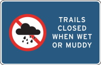
- Please avoid riding in wet/muddy conditions, especially in the Spring or after heavy rains.
- You may encounter hikers, trail runners and dog walkers. Bikes are not allowed on the ski trails.
DWP Multi-Use Trail
The DWP (Duluth, Winnipeg, and Pacific) trail is a retired railroad grade, refurbished and hardened by the City of Duluth for use as a multi-use trail. Including the connector, it offers 4 miles of trail end-to-end.
- Access to the DWP trail is just east (right, on exit) of the parking lot a couple hundred meters, and down the wide, packed gravel Clyde Connector trail.
- DO NOT ride on the Superior Hiking Trail, which exits the back corner of the parking area and also crosses the Clyde Connector. This is a narrow, foot-travel only trail.
- The DWP is multi-use, and a popular route for hikers/runners, bikers and horse riders.
- Please make sure your horse is sensitized to bike riders and other non-equestrian users!
- Other non-equestrian users may not be familiar with horses and etiquette.
- A couple miles out, there is a dark railroad tunnel through the mountain that may be scary for horse and rider.
- Bring a headlamp and warn any bikers as best you can.
West Skyline Parkway
| NOTE: West Skyline Parkway will be closed for the 2025 season, from the Magney-Snively parking lot to the western city limits. City of Duluth work will be active, including culvert replacements, ditch improvements, retaining wall rehabilitation and interpretive marker instalation. This closure does not affect the Magney-Snively / Elys Peak Loop, which intersects West Skyline. However, please be alert and cross with care. |
West Skyline Parkway heading west (left) from the parking lot is open to horses, including in the winter when the road is closed. It offers 3.5 miles end-to-end.
- Surface is mixed gravel road.
- From late spring to late fall this road is open to vehicle traffic, generally light/periodic.
- Please make sure your horse is sensitized to vehicles.
- Be aware that some turns may have short sight lines.
Hawk Ridge Area
- Parking is at the Snively Trail parking area – HERE.
- Trail map is available – HERE (courtesy of the City of Duluth)
- Additional information is also available from the City of Duluth Equestrian Trails page.
Amity Creek Trail
The Amity Creek Trail is a retired gravel road grade, now designated for use as a multi-use trail. It offers 2 miles of trail end-to-end to where it ends at Colby Ave.
- Access to the trail is off the back corner of the parking lot.
- The Amity Creek Trail is multi-use, and a popular route for hikers/runners, bikers and horse riders.
- Please make sure your horse is sensitized to bike riders and other non-equestrian users!
- Other non-equestrian users may not be familiar with horses and etiquette.
East Skyline Parkway
Near the west end of the Amity Creek Trail, a trail heads south connecting to the gravel East Skyline Parkway. Combined with the Amithy Creek Trail portion, one can create a loop just over 4 miles.
- East Skyline Parkway is mixed gravel road.
- From late spring to late fall this road is open to vehicle traffic.
- Please make sure your horse is sensitized to vehicles.
- During the raptor migration seasons (Mar-May, Aug-Nov), traffic can increase significantly.
Jay Cooke State Park
- Parking is at the lot across from Forbay Dam on Jay Cooke Rd. – HERE.
- This lot is limited in size. Parking is also available adjacent along Jay Cooke Rd.
- Trail map is available – HERE (courtesy of the MN DNR)
Forbay Trail
The Forbay Trail is a packed gravel path that runs along the resevoir across the road from the parking area. Just in from the parking area, the trail dips down to the base of the spillway, then returns back up to the resevoir edge. It offers 1.4 miles end-to-end.
- The Forbay Trail eventually turns to asphalt, which is not a horse trail.
- Hiking trails connect to the Forbay Trail near the bottom of the spillway. These are not horse trails.
Greeley Trail
The Greeley Trail heads east from the parking area, angling up and running alongside the Munger Trail 0.9 miles to the Triangle and Oak Trails.
- The trail runs immediately alongside the Munger Trail, which is a popular biking trail.
- Please make sure your horse is sensitized to bikes.
Triangle / Oak Trails
The Triangle and Oak Trails can be accessed from the Greeley Trail. They provide an additional 2.3 miles (Triangle) and 1.8 miles (Oak) of riding.
- Walkers/runners and dogs are not uncommon. Bikes are also allowed on these trails, but tend to be infrequent.
Boulder Lake Management Area
- The area is divided into two sections:
- Trail map is available – HERE (courtesy of the BLMA)
North & South Trail Systems
All of the trails at the Boulder Lake Management Area are multi-use trails open to riding. The trails are primarily grassy, cross-country ski trails. No motorized vehicles are allowed.